
Hiking Emigrant Peak In Montana’s Absaroka Range
Location: Emigrant Peak, Absaroka Range, Gallatin National Forest, Montana
Type: Peak
Rating: Grade II Class 2
Trailhead: Gold Prize Trailhead – 5,900′
Distance: 7.5 miles round trip
Time: 5 to 9 hours round trip
Emigrant Peak Elevation: 10,921′
Total Vertical: 5015′
Lat/Long: 45.26000°N / 110.69°W
USGS Maps: Dailey Lake, Emigrant
Weather Forecast: Emigrant Peak Weather
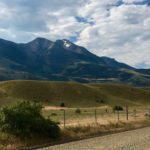
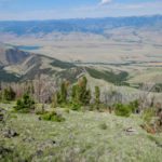
Emigrant Peak sits at 10,921′ at the western edge of the Absaroka Range/Western Beartooths in Montana. The summit of Emigrant sits roughly 6000′ higher than the Yellowstone River as it flows north out of Yellowstone National Park in the Paradise Valley. Anyone who drives along Highway 89 will be in awe of Emigrant Peak as it dominates the skyline. It’s a beast of a mountain, but a relatively straightforward hike, which is why it’s definitely a SW Montana classic.

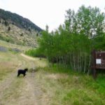
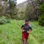
Study your USGS maps and get a lay of the land before you head out. There are two main routes up Emigrant. One route starts by following the mining road from Chico via Emigrant Gulch. There are a few private mining claims on this route making access a bit more challenging. The standard route to climb Emigrant Peak is via the south side starting at Gold Prize Creek. It’s a steep hike with minimal approach making it the ultimate stair master workout. This is the route that Catfish Tenny, Ozzie The Dog, and I decided to go with on a busy Saturday in July.

To access the Gold Prize Trailhead, take the East River Road and turn onto the well maintained gravel Sixmile Creek Road toward Dailey Lake and Sixmile Creek. Turn at the gate towards Sixmile Creek. You’ll want 4×4 or at least decent clearance from this point on. The road eventually forks. Take the left fork – you’ll be able to see Emigrant Peak towering overhead at this point. Follow this short spur road north toward Gold Prize Creek Trailhead at 5900′. The parking area is just shy of the gate. Park here or prior to this depending on the numbers of cars at the trailhead.


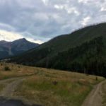
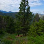
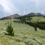
Arm yourself with bear spray and bear calls and hit the trail as it follows an old mining road along the north side of Gold Prize Creek. After about a mile, the trail turns steadily uphill to about 7100′. From here an old mining road contours east for about a quarter mile. Then the trail ramps up the angle and climbs steadily to the huge meadow at 7500′.


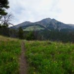
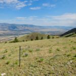
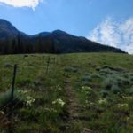
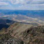
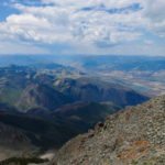
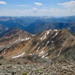
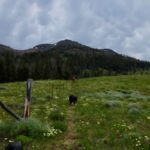
As you enter the meadow, the views are impressive of both your route up Emigrant, the Paradise Valley, and the Gallatin Range. The trail is pretty easy to follow as it follows an old barbed wire ranching fence up the meadow to roughly 8300′ at treeline.


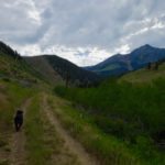
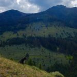
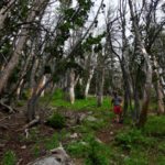
At the treeline, the trail gets a bit harder to follow. We ventured south on a faint trail until we decide to bushwhack through some openings in the forest back toward the NW ridge. Alternatively, you can continue up the ridgeline through the thick forest. On our way down, we found a trail that made it a good way through the forest, but never connected to the meadow trail. Maybe me just missed it? Choose your own adventure here.


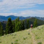
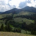
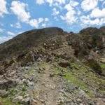
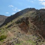
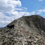
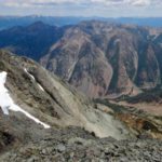
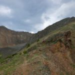
Eventually you’ll break out of the forest at roughly 9300′. From here you’ll be on the rocky Northwest Ridge of Emigrant Peak. There is a faint trail that weaves in and out of the rocks. It’ s a very straightforward Class 2 scramble. There is no real exposure and the trail is pretty easy to follow along the ridge. Ozzie The Dog had no issues navigating this terrain. Overall the hike is quite dog friendly, despite the only water being in Gold Prize Creek.


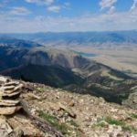
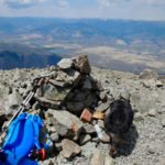
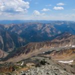
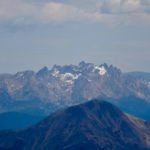
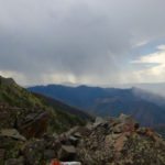
Just before the final summit is the most exposed section of ridge, but it’s easy to navigate when dry. Might be a different story if there was snow on the peak. The summit is marked with USGS marker and a large cairn. Sit back and enjoy the views of the Gallatin Range, Crazy Mountains, Bridger Range, Madison Range, Absaroka-Beartooth Wilderness, Yellowstone National Park, and beyond. On a clear day you can spot Cowen, Lone Mountain, Sphinx, Electric, and even the Tetons. Take a good look around because Emigrant is a ski mountaineering paradise in winter. Here’s a link to a spring skiing trip report on Emigrant.


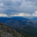
Despite the decent weather, we could hear distant thunder claps so we decided to boogie down after a quick bite to eat and a bit of water. We were glad to reach the treed section as the thunderstorms rolled in quicker than expected. The return route was the same as the ascent route. Just follow your tracks back down. It’s certainly a leg burner both up and down so be sure to pace yourself. Once back at the car, head back down the road you came in on. Perhaps the best way to end the day is to head to Chico Hot Springs for a soak and a brew.


Learn more about Emigrant Peak in Turiano’s book Select Peaks of the Greater Yellowstone. This is a must-have book for anyone who loves bagging peaks in this region.
For our adventure to hike Emigrant Peak in the Montana Absarokas, we tagged the summit in 3.75 hours and our descent took 2.5 hours. Add in a quick summit party and our car to car hike of Emigrant Peak took 6.5 hours. Definitely add Emigrant to Montana peak bagging bucket list. This is one massive mountain.

View route of our climb of Emigrant Peak Montana on HillMap:
Additional photos from hiking Emigrant Peak Montana:
This trip report for hiking Emigrant Peak in Montana’s Absaroka Range is from July 8, 2017.
#mountainjourney #absaroka #montana #eternalstoke #emigrantpeak #paradisevalley #selectpeaks


