
Climbing Hilgard Peak In Montana’s Madison Range
Location: Hilgard Peak, Taylor Hilgard Unit, Lee Metcalf Wilderness, Madison Range, Montana
Type: Peak
Rating: Grade III Class 4+
Trailhead: West Beaver Creek Trailhead – 6,907′
Distance: 17.15 miles round trip
Time: 9 to 13 hours round trip
Hilgard Peak Elevation: 11,316”
Total Vertical: 5650′
Lat/Long: 44.91640°N / 111.4597°W
Maps: Hilgard Peak, Pika Point
Find More Montana Trip Reports
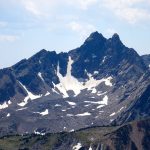
Hilgard Peak sits at 11,316′ in the Taylor Hilgard Unit of the Lee Metcalf Wilderness in the Beaverhead National Forest of the Madison Range of Montana. Hilgard is the highest peak in the Madison Range and the highest peak in Montana outside of the Beartooth Mountains.

Turiano’s book, Select Peaks Of Greater Yellowstone, provides an in-depth look at Hilgard Peak. The peak was named after Professor E.W. Hilgard, who worked for the USGS in the mid-to-late 1800’s. Dave Wessel made the first ascent on Memorial Day 1948 by skis in one day.

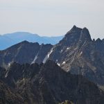
Access to Hilgard Peak is challenging. It’s a remote peak and can only be spotted from the road in a few places – including near Hebgen Lake. Most peak baggers use the West Beaver Creek Trailhead along FS Road 985 – although Hilgard can be approached numerous different ways.

On a smokey August day, Jeremy Wood and I decided to climb Hilgard Peak. Driving down Highway 191 in the dark, we turned west on Highway 287 past Hebgen Lake. As we drove along in the morning light, we could just make out the pronged summit of Hilgard Peak in the distance.
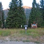
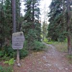
Soon we turned on US Forest Service Road #985. We followed the dirt road north for roughly 3 miles until we saw a pullout on the west side of the road for the West Beaver Creek Trailhead – 6907′. We laced up our boots, packed our bear spray, and hit the trail.

Trail #222 immediately drops down and crosses Sentinel Creek. It then enters the Lee Metcalf Wilderness and wraps to the west. The trail follows the steep flanks of the mountain side high above the West Fork of Beaver Creek.


After 4.65 miles, the trail splits at 8550′. Trail #222 continues on to Blue Danube Lake and Trail #152 heads to the NW toward Avalanche Lake. It took us 1.75 hours and 1715′ to reach this point.


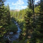
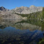
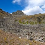
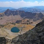
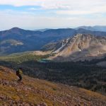
We followed the trail to Avalanche Lake at 9015′. We reached the lake in 5.75 miles, 2.25 hours, and 2225′. There are some large fish in this lake and some well established campgrounds.

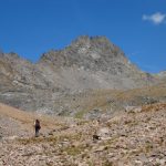
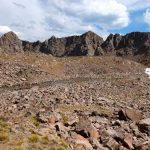
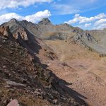
We skirted around the north side of the lake and followed mellow off-trail terrain up toward the ridge to the north. There were a handful of unnamed lakes and the walking was straightforward.
A grassy ramp with large boulders made for easy walking to the ridgeline between Avalanche Lake and Hilgard Peak. We ended up a bit west of the saddle at roughly 10250′, but it seemed to work out just fine. It took us 3.75 hours, 7.45 miles, and 3610′ to reach this point.


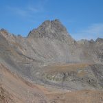
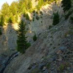
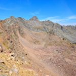
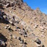
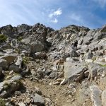
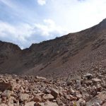
From here we dropped about 500′ into the basin south of Hilgard Peak. This section was steep, loose, and firm. It took longer than planned due to conditions.

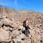
Once at the bottom of the slope we had a long walk across uneven terrain, boulder fields, and steep moraines toward the base of Hilgard Peak.


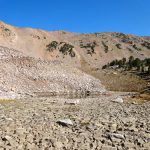
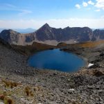
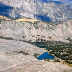
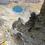
We crossed directly across the empty Lake Elise and upwards toward the unnamed lake at 10,465′ below Hilgard Peak. We reached this lake before our final approach in 8.5 miles, 5 hours, and 4275′. The lake is stunning as is the entire cirque. We even had 1x cell phone service with Verison at this point.


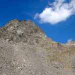
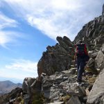
We chose to ditch a bit of weight here in order to travel to the peak fast and light. We quickly climbed about 400′ up scree and grass to the East col below Hilgard Peak’s east ridge at 10,900′. From here, the climb gets a bit more serious.


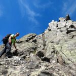
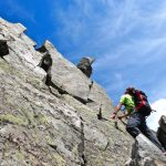
We based our route selection on Turiano’s description – including his warning “Experienced mountaineers will not need a rope for this climb, but novices would be in danger without.” We had a rope and all the gear. Ultimately we did not use it, but maybe should have.
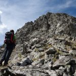
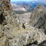
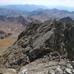
As you can see in our photos, we climbed up loose rocks and slabs toward the gully that has a shadow in it. As we neared the shadow we worked right toward the ridgeline. Then a grassy slope opens up above the exposed gully. A few crux moves with solid hand and foot holds allowed us to cross over the exposure into a steep and loose gully above the shadow.


We climbed this gully up and then worked left onto another grassy slope. From here we climbed worked up a few ledges and climbed a small crack back right on to the ridge line.


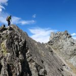
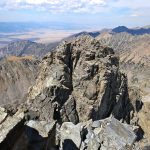
Then we followed the ridgeline up to the top – only to realize that this was the 5.2 knife edge ridge that drops significantly to the west and a bit less significantly to the east. We downclimbed back and crossed easy and exposed terrain to a small gully that reach the col directly below the summit. A few more steps and were on the summit of Hilgard Peak.


We reached the summit in 6.25 hours, 8.9 miles, 5000′ up and 560′ down. Our final ascent route sounds a bit complicated, but it’s pretty straightforward as long as you are willing to sniff out the proper route. Turiano rates this climb as a III Class 4. I think easy 5th class could also be argued.
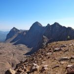
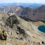
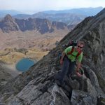
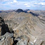
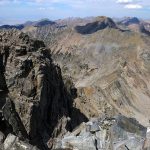
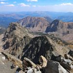
From the south summit of Hilgard Peak the views were mind blowing. The south summit is definitely the higher of the two summits. It would be fun to traverse to the north summit, then continue on to Dutchman and Echo Peak – a classic Madison Range Traverse. Not in the cards today though.


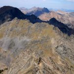
Instead we enjoyed the views – Echo Peak, Dutchman Peak, Sentinel Peak, Peak 10930, Imp, Koch, Hebgen Lake, and so many unnamed peaks spread out in all directions. Numerous colorful lakes spotted the basins far below. It was unreal and I took way too many photos.


After a leisurely half hour on the summit of Hilgard we decided we must go. It was still a long ways home. We carefully downclimbed our ascent route. We grabbed our gear near the unnamed lake and hustled back across the basin to the distant ridgeline.

The climb back to the ridge about Avalanche Lake was quick, but definitely challenging terrain. But at the top it was all downhill. We cruised down to Avalanche Lake, refilled our water bottles, and set our legs on autopilot down the trail and back to the car.

Round trip our adventure to climb Hilgard Peak took 11 hours. We covered 17.18 miles and 5650′. Always a blast to climb a new mountain – especially when it’s the highest in the range. Hope to ski it next time.
Watch panorama views from the summit of Hilgard Peak:
View route of our climb of Hilgard Peak Montana on HillMap:
Additional photos from climbing Hilgard Peak in Montana:
This trip report for Hilgard Peak in Montana’s Madison Range is from August 29, 2016.
#amountainjourney #madisonrange #montana #eternalstoke


