
Hiking Koch Peak In The Madison Range
Location: Koch Peak, Taylor Hilgard Unit, Lee Metcalf Wilderness, Madison Range, Montana
Type: Out and Back
Rating: Grade II, Class 2
Trailhead: Taylor Fork
Distance: 14 miles total
Time: 5 to 9 hours
Taylor Fork Trailhead Elevation: 7275′ | 2217 m
Koch Peak Elevation: 11,293′ | 3442 m
Total Vertical: 4075′
Maps: Koch Peak, Lincoln Mountain or Beartooth Publishing Maps
_____________________________________________________________
Whenever I look south toward the Taylor Hilgards, my eyes are drawn to Koch Peak. Koch Peak sits at 11,293′ at the northern end of the Taylor Hilgard unit of the Lee Metcalf Wilderness. It’s easily recognizable when viewed from the northern Madison Range and can be seen from both the Madison and Gallatin. It’s an impressive peak. Learn more about it in Turiano’s Select Peaks of the Greater Yellowstone.

Last winter I had the opportunity to ski the Notch on Koch, a classic couloir. But I’ve always wanted to stand on top of it during the summer too. So on September 11, Jeremy Wood and I woke up early and went for a walk.

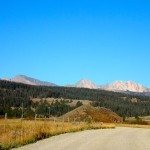
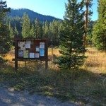
To reach Koch Peak, we turned on to Montana Highway 191 toward the Taylor Fork Road (FS Road 134). The turnoff is 14.3 miles south of the Big Sky stoplight. The Taylor Fork Road is a dirt road that has some rough patches. Follow the road for 10.6 miles to the Taylor Fork Trailhead. You’ll pass a ranch and an airstrip. Pay attention to the skyline because you’ll see Koch in the distance as you drive in. Turn left at a poorly marked road split at about mile 8.5. After you cross the bridge over Taylor Creek, there’s a big trailhead sign at 7,275′ to greet you.

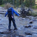
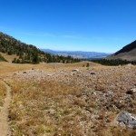
At the trailhead, we got our gear together and started the walk down FS Trail #17. We made lots of noise as the Taylor Hilgards has one of the largest concentrations of grizzly bears in the Lower 48. The trail follows the south side of Taylor Creek for about half a mile before it crosses it to the north side.

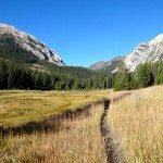
Once on the north side, the trail continues through the forests and open meadows along the creek for about 1.3 miles to a trail junction with Tumbledown Trail (#4). Along the way, there are fantastic views of Woodward Mountain and Peak 10764. The trail split is well marked and would be hard to miss.

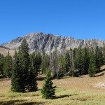
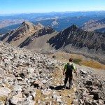
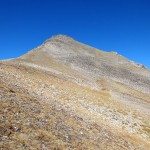
From here the trail climbs steadily through the forest. After 2.3 miles you’ll pass another trail junction. At this point you’ll be able to see Koch towering over you in the distance. The 1,000 foot walls of gneiss and schist look intimidating, but the south face is nice and mellow. In another .6 miles the trail will fizzle out at about 9,525′ and you’ll be left to your own devices.

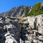
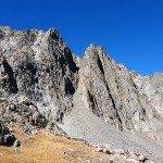
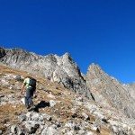
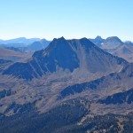
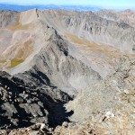
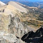
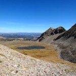
At the end of the trail, head cross country across mellow terrain and rolling moraines. We chose to scurry up an obvious, mellow gully that parallels the northwest ridge. In no time, you’ll find yourself gawking at the snowless Notch on Koch and other couloirs running down the rocky walls. Across the basin, the slanted slabs and crumbling rock look other worldly. It’s an amazing place.


The easiest way to summit is to continue up the drainage to the saddle and then scramble up the south face to the peak. Obviously we didn’t do that. Instead we scrambled up the steeper face – meeting the south ridge about 2/3 of the way up. We still easily made the summit in 3 hours 20 minutes. In total we covered 6.75 miles and 900 vertical feet since leaving the car.


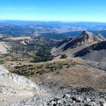
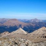
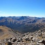
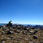
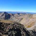
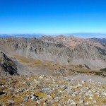
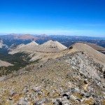
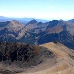
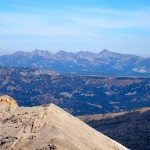
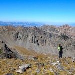
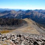
When you stand on top of Koch Peak at 11,293′, you feel like you’re on top of the world. The views of the Madison Range are jaw dropping. In the distance to the north you can see the Spanish Peaks, Lone Mountain, and Sphinx. To the south you can see Imp, Echo, and Hilgard. You can even see a sliver of Hebgen Lake. Nutters Cathedral, No Man Peak, Sawtooth Ridge, and so many unnamed zones beckon to be explored. Imagine all of the skiing that needs to get done…


The broad summit is a fantastic place to sit back and soak in the views. Stick around for awhile and appreciate nature.


Unfortunately, for us we had to boogie as Jeremy had to get back to work. Driven by gravity, we followed the easy way back down the south ridge to the saddle.


We stopped only once to grab some water and found that we were back at the car in no time. Car to car our adventure to hike Koch Peak took 6.25 hours. We covered 13.5 miles and 4075′. Not a bad way to spend a day. I’ll be back.
_____________________________________________________________
View the route on HillMap:
_____________________________________________________________
Here’s a 360 degree video from the summit of Koch Peak:
_____________________________________________________________
Check out a few additional photos from hiking Koch Peak:

_____________________________________________________________
This trip report is from September 11, 2015.


