
Hiking Table Mountain In Montana’s Madison Range Via The Deer Creek Trail
Location: Table Mountain, Madison Range, Montana
Type: Peak
Rating: Grade I Class 1
Trailhead: Deer Creek Trailhead – 5874′
Distance: 14 Miles
Time: 5 to 8 hours
Elevation Table Mountain: 9,851′ | 3003 meters
Total Vertical: 4000′
Lat/Long: 45 19.9029, 111 15.1804
Maps: Gallatin Peak, Hidden Lake
Find More Montana Trip Reports
There’s nothing better than going for a hike in Big Sky Country on a bluebird July day. There are so many places to explore in the Madison Range, but one place Jeremy Wood and I hadn’t been to yet was Table Mountain. Table Mountain is the 275th highest peak in Montana and I believe it is the 31st highest named peak in the Madison Range. Definitely worth a hike and the trail goes right to the top.

Table Mountain sits at 9,851′ in the Madison Range of Montana. There’s a trail that leads almost right to the summit and it can easily be accessed from three different trailheads located in the Gallatin Canyon – Deer Creek, Asbestos Mine, and Cascade Creek. We opted to hike Table Mountain via the Deer Creek trail because it is the most direct and shortest route.
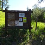
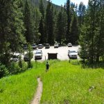
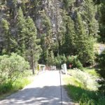
After waiting in a bit of Highway 191 traffic in the Gallatin Canyon, we turned off at Highs Bridge aka the Green Bridge and parked at the Deer Creek Trailhead at 5874′. We laced up our boots and started hiking up the Deer Creek Trail (#481) at the crack of 9:30 AM.

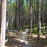
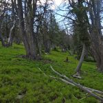
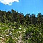
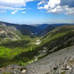
Within a few minutes of walking we entered the Spanish Peaks unit of the Lee Metcalf Wilderness. The trail has a beautifully mellow grade. It’s not too steep, but you still climb steadily. The trail weaves in and out of meadows and thick forests for the first several miles.


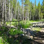
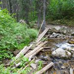
Just after mile 3, we crossed a nice bridge and started going up some switchbacks. Then at 3.75 miles we crossed Deer Creek again via a log bridge that is lashed together. There’s a massive, human-made pile of rocks here that’s quite strange. The trail continues to switchback through forests and meadows as we headed toward our destination.


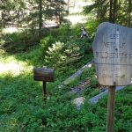
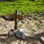
On the map there is a triangle of trails at roughly 4.7 miles, we never saw the first turn off. Instead at roughly 5+ miles we hit the well-marked main intersection of the Deer Creek Trail (#481) and Table Mountain Trail (#445) at approximately 8750′. The Table Mountain Trail obviously sees less traffic than the Deer Creek Trail, which heads on to Moon Lake and Deer Lake.


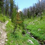
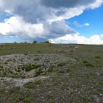
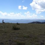
The Table Mountain Trail mellowly climbs up through lush leprechaun green forests and eventually hits a small saddle between the Deer Creek Drainage and the Cascade Creek Drainage at about 9450′. We had 3G service here with clean views to Bozeman and beyond.


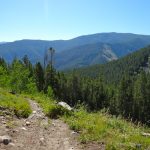
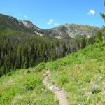
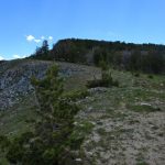
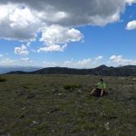
At this point, the trail seems to fade away. It’s still well marked with large cairns. The terrain is very mellow and gradually reaches the wide open summit. The summit is not a prominent point, but more of a large plateau with a few trees scattered about. Near the top there are some holes in the ground that must be old mining claims. These are marked as Prospects X’s on the USGS maps. We reached the summit in 3.5 hours after covering 7 miles and 4000′.


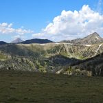
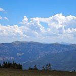
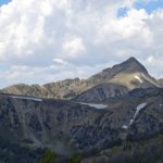
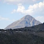
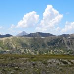
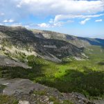
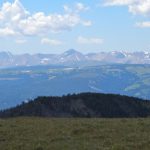
The views from the summit are outstanding. The Taylor Hilgards and the Monument unit dominate the southern skyline. Wilson Peak and Lone Mountain are visible to the west. The entire Gallatin Range dominates the eastern skyline with towering peaks from the Absaroka-Beartooth Range in the distance.


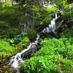
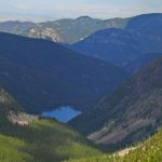
A short walk to the north and the Cascade Creek drainage opens to Lava Lake and on the distant skyline the Bozeman valley and the Bridgers are visible. It’s amazing.


Unfortunately, we only had time for a quick bite to eat and a drink of water because of work obligations and quickly turned around and headed back the way we had come. We headed directly back to the saddle and then followed the trail back to the Deer Creek Trailhead and the car. If we had more time it would have been a perfect opportunity to take a dip in the Gallatin River or jump off of the Green Bridge, but that will have to wait until next time.

Round trip, we covered 13.75 miles and 4000′ in 5.75 hours. Another awesome day in the #madisonrange of #montana.
If I could do one thing different on this very straightforward hike, I might continue on from the summit of Table Mountain and follow the trail onwards to either the Asbestos Mine Trail and back down to the Gallatin Canyon OR head onwards to Lava Lake and down the Cascade Creek Trail which ends at the 35 MPH bridge in the canyon. Both of these hikes follow trails the entire way, but would require a car shuttle, which we didn’t have time for logistically today.
View route from Deer Creek To Table Mountain in Montana’s Madison Range via HillMap:
If you wanted to make this hike even better, shuttle a car to either Asbestos Mine Trailhead or Cascade Creek Trailhead. Then you can go up Deer Creek and down a different way or vice versa. Here are maps for:
- Deer Creek to Table Mountain to Asbestos TH – Approximately 14.5 Miles
- Deer Creek to Table Mountain to Lava Lake to Cascade Creek TH – Approximately 14.6 Miles
Additional photos from hiking Table Mountain:
This trip report for hiking Table Mountain in Montana’s Madison Range is from July 19, 2016.
#amountainjourney #madisonrange #bigsky #montana #tablemountain


 is a peak in the Madison Range of Montana that can be hiked from multiple trailheads in the Gallatin Canyon. TR follows Deer Creek.)