
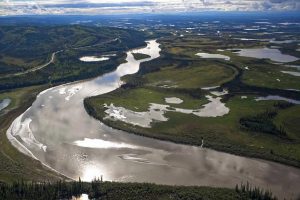
The US Fish & Wildlife Service manages the 150-million acre National Wildlife Refuge System. The goal of this vast system of public lands and waters is to “administer a national network of lands and waters for the conservation, management, and where appropriate restoration of fish, wildlife, and plant resources and their habitats within the United States for the benefit of the present and future generations of Americans.”
![]()
Since then, the National Wildlife Refuge System has grown rapidly. Today the National Wildlife Refuge System is responsible for managing roughly 150 million acres of land and water from the Caribbean to the remote Pacific.
Mountains, wetlands, prairies, marine areas, forests, arctic, alpine, grasslands, and other landscapes are protected within the NWRS. These special places “provide habitat for more than 700 species of birds, 220 species of mammals, 250 reptile and amphibian species and more than 1,000 species of fish. More than 380 threatened or endangered plants or animals are protected on wildlife refuges” (FWS.gov).
Nearly 50 million people visit the National Wildlife Refuge System every year. According to RefugeAssociation.org, the NWRS generates “$2.4 billion for local economies and create nearly 35,000 U.S. jobs annually.”
The National Wildlife Refuge System is an ideal places for outdoor recreation like “wildlife-watching, hunting, fishing, photography, hiking, canoeing, kayaking and environmental education.” Maybe it’s time for you to add these incredible destinations to your bucket list.
According to the USFW Annual Report Of Lands Data, as of September 2017, there are 566 National Wildlife Refuges that consist of 146,432,080.08 total acres. In total the National Wildlife Refuge System manages 855,585,128.79 total acres. That includes Wildlife Refuges, Monument Areas, Waterfowl Production Areas, Coordination Areas, Fish Hatcheries, and administration sites. The list below is based on that annual report.
For full statistics on the National Wildlife Refuge System, please consult that report. The best map of the National Wildlife Refuge System can be found here.
Below you can explore the National Wildlife Refuge System listed by state based on information from FWS.gov:
Alabama – 11 Units – 71,573.13 acres
- Bon Secour
- Cahaba River
- Choctaw
- Eufaula
- Fern Cave
- Grand Bay
- Key Cave
- Mountain Longleaf
- Sauta Cave
- Watercress Darter
- Wheeler
Alaska – 16 Units – 76,797,990.87 acres
- Alaska Maritime
- Alaska Peninsula
- Arctic
- Becharof
- Innoko
- Isembek
- Kanuti
- Kenai
- Kodiak
- Koyukuk
- Nowitna
- Selawik
- Tetlin
- Togiak
- Yukon Delta
- Yukon Flats
American Samoa – 1 Unit – 1,613.00 acres
- Rose Atoll
Arizona – 9 Units – 1,736,885.77 acres
- Bill Williams River
- Buenos Aires
- Cabeza Prieta
- Cibola
- Havasu
- Imperial
- Kofa
- Leslie Canyon
- San Bernardino
Arkansas – 10 Units – 381,658.21 acres
- Bald Knob
- Big Lake
- Cache River
- Felsenthal
- Holla Bend
- Logan Cave
- Overflow
- Pond Creek
- Wapanocca
- White River
California – 39 Units – 501,661.15 acres
- Antioch Dunes
- Bitter Creek
- Blue Ridge
- Butte Sink
- Castle Rock
- Clear Lake
- Coachella Valley
- Colusa
- Delevan
- Don Edwards San Francisco Bay
- Ellicott Slough
- Farallon
- Grasslands
- Guadalupe-Nipomo Dunes
- Hopper Mountain
- Humboldt Bay
- Kern
- Kesterton
- Lower Klamath
- Marin Islands
- Merced
- Modoc
- North Central Valley
- Pixley
- Sacramento
- Sacramento River
- Salinas River
- San Diego
- San Diego Bay
- San Joaquin River
- San Luis
- San Pablo Bay
- Seal Beach
- Sonny Bono Salton Sea
- Stone Lakes
- Sutter
- Tijuana Slough
- Tule Lake
- Willow Creek-Lurline
Colorado – 10 Units – 340,513.78 acres
- Alamosa
- Arapahoe
- Baca
- Browns Park
- Colorado River
- Monte Vista
- Rocky Flats
- Rocky Mountain Arsenal
- Sangre de Cristo
- Two Ponds
Connecticut – 2 Units – 1697.49 acres
- Silvio O. Conte
- Stewart B. McKenney
Delaware – 2 Units – 26,496.18 acres
- Bombay Hook
- Prime Hook
Florida – 30 Units – 990,238.13 acres
- Archie Carr
- Arthur R. Marshall Loxahatchee
- Caloosahatchee
- Cedar Keys
- Chassahowitzka
- Crocodile Lake
- Crystal River
- Egmont Key
- Everglades Headwaters
- Florida Panther
- Great White Heron
- Hobe Sound
- Island Bay
- J.N. “Ding” Darling
- Key Deer
- Key West
- Lake Wales Ridge
- Lake Woodruff
- Lower Suwannee
- Matlacha Pass
- Merritt Island
- Okefenokee
- Passage Key
- Pelican Island
- Pine Island
- Pinellas
- St. Johns
- St. Marks
- St. Vincent
- Ten Thousand Islands
Georgia – 8 Units – 496,736.91 acres
- Banks Lake
- Blackbeard Island
- Bond Swamp
- Harris Neck
- Okenfenokee
- Piedmont
- Wassaw
- Wolf Island
Guam – 1 Unit – 23,228.10 acres
- Guam
Hawaii – 10 Units – 304,733.60 acres
- Hakalau Forest
- Hanalei
- Hawaiian Islands
- Hule’ia
- James Campbell
- Kakahaia
- Kealia Pond
- Kilauea Point
- Oahu Forest
- Pearl Harbor
Idaho – 6 Units – 85,280.92 acres
- Bear Lake
- Camas
- Deer Flat
- Grays Lake
- Kootenai
- Minidoka
Illinois – 12 Units – 131,085.65 acres
- Chautauqua
- Crab Orchard
- Cypress Creek
- Emiquon
- Great River
- Hackmatack
- Kankakee
- Meredosia
- Middle Mississippi River
- Port Louisa
- Two Rivers
- Upper Mississippi
Indiana – 3 Units – 69,011.09 acres
- Big Oaks
- Muscatatuck
- Patoka River
Iowa – 5 Units – 88,370.88 acres
- DeSoto
- Driftless Area
- Neal Smith
- Northern Tallgrass Prairie
- Union Slough
Kansas – 5 Units – 67,795.67 acres
- Flint Hills
- Flint Hills Legacy
- Kirwin
- Marais des Cygnes
- Quivira
Kentucky – 3 Units – 11,837.75 acres
- Clarks River
- Ohio River Islands
- Reelfoot
Louisiana – 23 Units – 599,113.75 acres
- Atchafalaya
- Bayou Cocodrie
- Bayou Sauvage
- Bayou Teche
- Big Branch Marsh
- Black Boyou Lake
- Bogue Chitto
- Breton
- Cameron Prairie
- Cat Island
- Catahoula
- D’Arbonne
- Delta
- Grand Cote
- Handy Brake
- Lacassine
- Lake Ophelia
- Mandalay
- Red River
- Sabine
- Shell Keys
- Tensas River
- Upper Ouachita
Maine – 10 Units – 72,948.17 acres
- Aroostook
- Cross Island
- Franklin Island
- Moosehorn
- Petit Manan
- Pond Island
- Rachel Carson
- Seal Island
- Sunkhaze Meadows
- Umbagog
Maryland – 6 Units – 49,786.16 acres
- Blackwater
- Chincoteague
- Eastern Neck
- Glenn Martin
- Patuxent
- Susquehanna River
Massachusetts – 10 Units – 23,387.72 acres
- Assabet River
- Great Meadows
- Mashpee
- Massasoit
- Monomoy
- Nantucket
- Nomans Land Island
- Oxbow
- Parker River
- Thacher Island
Michigan – 8 Units – 126,050.38 acres
- Detroit River International
- Green Bay
- Harbor Island
- Huron
- Kirtlands Warbler
- Michigan Islands
- Seney
- Shiawassee
Minnesota – 11 Units – 246,975.61 acres
- Agassiz
- Big Stone
- Crane Meadows
- Glacial Ridge
- Hamden Slough
- Mille Lacs
- Minnesota Valley
- Northern Tallgrass Prairie
- Rice Lake
- Rydell
- Sherburne
- Tamarac
Mississippi – 13 Units – 228,848.68 acres
- Coldwater River
- Dahomey
- Hillside
- Holt Collier
- Mathews Brake
- Mississippi Sandhill Crane
- Morgan Brake
- Panther Swamp
- Sam D. Hamilton Noxubee
- St. Catherine Creek
- Tallahatchie
- Theodore Roosevelt
- Yazoo
Missouri – 7 Units – 72,953.66 acres
- Big Muddy National
- Clarence Cannon
- Loess Bluffs
- Mingo
- Ozark Cavefish
- Pilot Knob
- Swan Lake
Montana – 24 Units – 1,334,910,28 acres
- Benton Lake
- Black Coulee
- Blackfoot Valley
- Bowdoin
- Charles M. Russell
- Creedman Coulee
- Grass Lake
- Hailstone
- Hewitt Lake
- Lake Mason
- Lake Thibadeau
- Lamesteer
- Lee Metcalf
- Lost Trail
- Medicine Lake
- National Bison Range
- Ninepipe
- Pablo
- Red Rock Lakes
- Rocky Mountain Front
- Swan River
- Swan Valley
- UL Bend
- War Horse
Nebraska – 7 Units – 155,392.72 acres
- Boyer Chute
- Crescent Lake
- Desoto
- Fort Niobrara
- John W. And Louise Seier
- North Platte
- Valentine
Nevada – 9 Units – 2,363,021.19 acres
- Anaho Island
- Ash Meadows
- Desert
- Fallon
- Moapa Valley
- Pahranagat
- Ruby Lake
- Sheldon
- Stillwater
New Hampshire – 3 Units – 36,156.19 acres
- Great Bay
- John Hay
- Wapack
New Jersey – 5 Units – 76,408.89 acres
- Cape May
- Edwin B. Forsythe
- Great Swamp National
- Supawna Meadows
- Wallkill River
New Mexico – 9 Units – 389,224.05 acres
- Bitter Lake
- Bosque del Apache
- Grulla
- Las Vegas
- Maxwell
- Rio Mora
- San Andres
- Sevilleta
- Valle De Oro
New York – 11 Units – 31,211.75 acres
- Amagansett
- Conscience Point
- Elizabeth A. Morton
- Great Thicket
- Iroquois
- Montezuma
- Oyster Bay
- Seatuck
- Shawangunk Grasslands
- Target Rock
- Wertheim
North Carolina – 12 Units – 435,422.08 acres
- Alligator River
- Cedar Island
- Currituck
- Great Dismal Swamp
- Mackay Island
- Mattamuskeet
- Mountain Bogs
- Pea Island
- Pee Dee
- Pocosin Lakes
- Roanoke River
- Swanquarter
North Dakota – 66 Units – 416,214.59 acres
- Appert Lake
- Ardoch
- Arrowwood
- Audubon
- Bone Hill
- Brumba
- Buffalo Lake
- Camp Lake
- Canfield Lake
- Chase Lake
- Cottonwood Lake
- Dakota Grassland
- Dakota Lake
- Dakota Tallgrass Prairie
- Des Lacs
- Florence Lake
- Half-Way Lake
- Hiddenwood
- Hobart Lake
- Hutchinson Lake
- J. Clark Salyer
- Johnson Lake
- Kellys Slough
- Lake Alice
- Lake George
- Lake Ilo
- Lake Nettie
- Lake Otis
- Lake Patricia
- Lake Zahl
- Lambs Lake
- Little Goose
- Long Lake
- Lords Lake
- Lost Lake
- Lostwood
- Maple River
- McLean
- North Dakota
- Pleasant Lake
- Pretty Rock
- Rabb Lake
- Rock Lake
- Rose Lake
- School Section Lake
- Shell Lake
- Sheyenne Lake
- Sibley Lake
- Silver Lake
- Slade
- Snyder Lake
- Springwater
- Stewart Lake
- Stoney Slough
- Storm Lake
- Stump Lake
- Sullys Hill National Game Preserve
- Sunburst Lake
- Tewaukon
- Tomahawk
- Upper Souris
- White Lake
- Wild Rice Lake
- Willow Lake
- Wintering River
- Wood Lake
Ohio – 3 Units – 9,408.27 acres
- Cedar Point
- Ottawa
- West Sister Island
Oklahoma – 9 Units – 173,465.51 acres
- Deep Fork
- Little River
- Optima
- Ozark Plateau
- Salt Plains
- Sequoyah
- Tishomingo
- Washita
- Wichita Mountains
Oregon – 21 Units – 583,313.61 acres
- Ankeny
- Bandon Marsh
- Baskett Slough
- Bear Valley
- Cape Meares
- Cold Springs
- Hart Mountain
- Julia Butler Hansen
- Klamath Marsh
- Lewis and Clark
- Malheur
- McKay Creek
- Nestucca Bay
- Oregon Islands
- Siletz Bay
- Three Arch Rocks
- Tualatin River
- Umatilla
- Upper Klamath
- Wapato Lake
- William L. Finley
Pennsylvania – 3 Units – 12,027.96 acres
- Cherry Valley
- Erie
- John Heinz
Puerto Rico – 5 Units – 22,584.46 acres
- Cabo Rojo
- Culebra
- Desecheo
- Laguna Cartagena
- Vieques
Rhode Island – 5 Units – 2,570.74 acres
- Block Island
- John H. Chafee
- Ninigret
- Sachuest Point
- Trustom Pond
South Carolina – 7 Units – 192,438.74 acres
- Cape Romain
- Carolina Sandhills
- Ernest F. Hollings ACE Basin
- Pinckney Island
- Santee
- Tybee
- Waccamaw
South Dakota – 5 Units – 125,042.27 acres
- Bear Butte
- Lacreek
- Lake Andes
- Sand Lake
- Waubay
Tennessee – 6 Units – 123,210.66 acres
- Chickasaw
- Cross Creeks
- Hatchie
- Lake Isom
- Lower Hatcie
- Tennessee
Texas – 20 Units – 641,682.73
- Anahuac
- Aransas
- Attwater Prairie Chicken
- Balcones Canyonlands
- Big Boggy
- Brazoria
- Buffalo Lake
- Caddo Lake
- Hagerman
- Laguna Atascosa
- Little Sandy
- Lower Rio Grande Valley
- McFaddin
- Moody
- Muleshoe
- Neches River
- San Bernard
- Santa Ana
- Texas Point
- Trinity River
Utah – 4 Units – 105,846.59 acres
- Bear River
- Bear River Watershed
- Fish Springs
- Ouray
US Minor Outlying Islands – Atlantic Islands – 1 Unit – 364,950.00 acres
- Narvassa Island
US Minor Outlying Islands – Pacific Islands – 10 Units 54,515,260.67 acres
- Baker Island
- Howland Island
- Jarvis Island
- Johnston Atoll
- Kingman Reef
- Mariana Arc Of Fire
- Mariana Trench Marine National Monument
- Midway Atoll
- Palmyra Atoll
- Wake Atoll
Vermont – 1 Unit – 34,187.27 acres
- Missisquoi
Virgin Islands – 3 Units – 590.15 acres
- Buck Island
- Green Cay
- Sandy Point
Virginia – 12 Units – 135,141.67 acres
- Back Bay
- Eastern Shore Of Virginia
- Elizabeth Hartwell Mason Neck
- Featherstone
- Fisherman Island
- James River
- Nansemond
- Occoquan Bay
- Plum Tree Island
- Presquile
- Rappahannock River Valley
- Wallops Island
Washington – 20 Units – 328,517.90 acres
- Columbia
- Conboy Lake
- Copalis
- Dungeness
- Flattery Rocks
- Franz Lake
- Grays Harbor
- Little Pend Oreille
- McNary
- Billy Frank Jr. Nisqually
- Pierce
- Protection Island
- Quillayute Needles
- Ridgefield
- Saddle Mountain
- San Juan Islands
- Steigerwald Lake
- Toppenish
- Turnbull
- Willapa
West Virginia – 1 Unit – 19,286.35 acres
- Canaan Valley
Wisconsin – 6 Units – 169,689.17 acre
- Fox River
- Gravel Island
- Horicon
- Necedah
- Trempealeau
- Whittlesey Creek
Wyoming – 7 Units – 86,431.21 acres
- Bamforth
- Cokeville Meadows
- Hutton Lake
- Mortenson Lake
- National Elk
- Pathfinder
- Seedskadee
The list of National Wildlife Refuges featured in this post is based on lists from Fish & Wildlife Service’s Annual Report Of Lands Data Table. Please visit FWS.gov for more information on the NWRS.
Did you know that the NWRS system is home to 20.6 million acres of designated wilderness? Here’s a fun video about wilderness within the National Wildlife Refuges:
Learn more about wilderness in the NWRS here.
See Also:
- Map & List Of National Parks By State
- The Wild And Scenic Rivers Of The United States
- List Of US National Forests By State


