
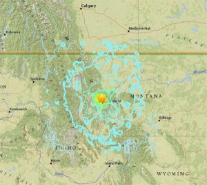
Lincoln, Montana – At 12:30am on Thursday, July 6, 2017 a 5.8 magnitude earthquake hit about 7 miles southeast of Lincoln, Montana. The shakes were felt for hundreds of miles. Luckily there were no reports of injuries or any major damage.
Measurable aftershocks struck the Montana region between 12:30 and 1:31 am, they reportedly ranged from 3.4 to 4.4 magnitude. Experts believe this event is not related to the Yellowstone Super Volcano. Nor is it related to the swarm of over 1100 smaller earthquakes in the Yellowstone Region over the past few weeks (ABCNews.go.com).
EarthQuake.USGS.gov reports that the M 5.8 earthquake southeast of Lincoln “occurred as the result of shallow strike slip faulting along either a right-lateral, near vertical fault trending east-southeast, or on a left-lateral vertical fault striking north-northeast. The location and focal mechanism solution of this earthquake are consistent with right-lateral faulting in association with faults of the Lewis and Clark line.”
While larger earthquakes are rare in Montana, they do occur in the region. EarthQuake.USGS.gov reports that “Western Montana, northwestern Wyoming, and eastern Idaho have experienced at least 16 other M 5.5+ earthquakes within 300 km of the July 6, 2017 event over the preceding century. The largest was the August 1959 M 7.2 Hebgen Lake earthquake – the largest historic event in the intermountain region.”
Learn more about the M5.8 – 11km SSE of Lincoln, Montana earthquake at EarthQuake.USGS.gov.


