
Climbing Finger Mountain In Montana’s Madison Range
Location: Finger Mountain, Taylor Hilgard Unit, Lee Metcalf Wilderness, Beaverhead National Forest, Madison Range, Montana
Type: Peak
Rating: Grade II Class 3
Trailhead: Sentinel Creek Trailhead – 7,150′
Distance: 22.5 miles round trip
Time: 8 to 12 hours round trip
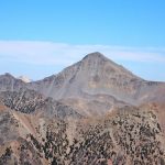
Finger MountainElevation: 10,738′
Total Vertical: 5875′
Lat/Long: 44.9819°N, 111.4924°W
USGS Maps: Hilgard Peak, Pika Point
Find More Montana Trip Reports
Finger Mountain sits at 10,738′ in the Taylor Hilgard Unit of the Lee Metcalf Wilderness in the Beaverhead National Forest in the Madison Range of Montana. It’s a hard peak to access due to the private land ownership on the west side of the Madison Range. With no easily accessible public trailheads coming from the west side of the range, Finger Mountain is a remote, isolated, and named peak that doesn’t see too many visitors.

When researching this peak, it was nearly impossible to find any beta about Finger Mountain. Besides one single 9-word line in Pat Caffrey’s book Climbers Guide to Montana, it seems like Finger Mountain barely even existed, which is why it’s an exciting peak to go and climb.

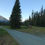
On a smokey August morning, Jeremy Wood and I headed to the Southern Madison Range to climb Finger Mountain. Pulling through West Yellowstone, we were overwhelmed by smoke from the Maple and Fawn fires. The smoke dissipated some as we turned west along Hebgen Lake. By the time the van was rumbling down FS road 985 toward Potamogeton Park (7150′) the smoke was essentially gone.
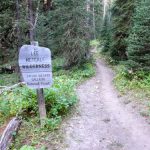
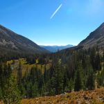
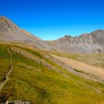
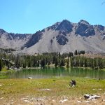
We parked at Potamogeton Park, got our gear together, and headed up the Sentinel Creek Trail #202. We were entering the Lee Metcalf Wilderness Area by 7:20 AM. The Sentinel Creek trail is a well trodden trail that climbs north and then swings west as it follows the Sentinel Creek.


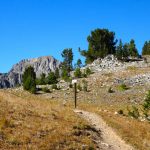
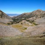
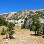
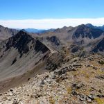
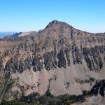
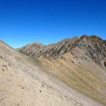
After about 6 miles we broke into the wide open basin below Expedition Pass. The trail continues up to the ridge line between Hilgard Basin and Sentinel Creek Basin. Take note that the trail split is not in the same place as it is marked on many maps – including the USGS maps. The trail splits on the ridge line NOT in the basin. The basin is massive and offers great views of Peak 10930, Sentinel Peak, and Peak 10844.

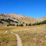
After 8 miles of walking, you’ll reach the trail junction. There’s an excellent view of Echo Peak dominating the skyline. We reached this point after 2.75 miles and 2850′ of elevation gain. Head west and follow the trail as it contours toward Expedition Pass at 10,085′. We reached Expedition Pass in 8.85 miles, 3.15 hours, and 3165′ of elevation gain.


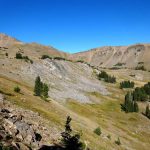
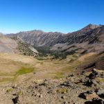
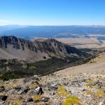
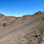
At the pass you get to gaze down into the seldom traveled Wolf Creek. The map marks a trail that drops down into Wolf Creek and then splits between Wolf Creek and Moose Creek. The trail doesn’t see much traffic and it’s hard to spot. Instead of following this map trail, we contoured west toward the pass between Wolf and Moose creeks following a mix of hiking trail, game trail, and instinct.


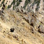
This trail sees some traffic, but it also involves lots of boulder hopping. As we approached the pass dropping toward Finger Lake and Moose Creek, a grizzly bear rolled over the same pass right in front of us. We had a bit of a stand off with this bruin. Bear sprays were in hand. With an unfriendly wind hitting us in the face, it was bit nerve wracking as the bear postured, grunted and groaned. t seemed like it really wanted to go in our direction. After about 5 minutes it turned, hid in the rocks, and disappeared. We eventually continued on to the pass when the bear reemerged – this time farther away. It had found another route into Wolf Creek.

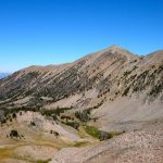
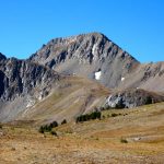
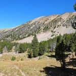
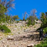
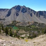
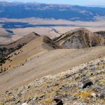
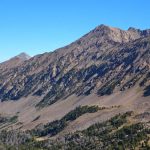
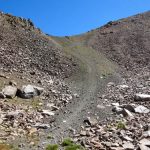
From this pass at 10030′ we had a clear view of Finger Mountain. The trail drops very steeply for about 100 feet and then it fades in and out as it continues downhill toward Finger Lake at 9285′. Around 9400′, 4.25 hours, and 10.6 miles, we turned off trail and started working our way up a steep path. The path was filled with loose rock and made for a steep scramble during the ascent. After the only one foot up, six inches down scree walking, we finally hit the ridge line between Finger Mountain and Peak 10626.


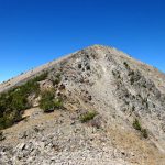
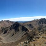
The final approach up the southeast ridge to the summit of Finger Mountain was easy walking. After 5.25 hours, 11.5 miles, 4680′ of gain and 1125′ of descent we stood on the top of this remote Madison Range peak. Cell phone service was strong on the summit. And the views were mind blowing.

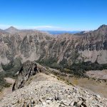
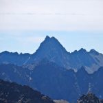
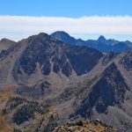
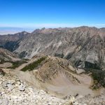
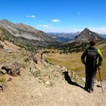
From the top, Koch Peak and the SW face of Imp Peak dominated the skyline. A keen eye could make out No Man Peak, Woodward Mountain, Cinnamon Mountain, Ramshorn Peak, and other summits. We had a clear view of our entire route from Expedition Pass to Finger Mountain. Peak 10722 stood proud above Finger Lake to the south. Numerous unnamed peak stood in front of Echo and Hilgard in the distance. And the Madison valley spread out to the west. Unreal.


The crazy thing was how close we were to the Madison Valley. This hike would have been short and sweet if we were able to access the Moose Creek or Wolf Creek trails that dead end into private land. And we could have walked up the east ridge, which is pretty mellow. Instead, we trekked halfway across a mountain range to stand on this peak. Worth the effort in my opinion.


After a leisurely summit break, we had to turn around. We went a bit west of our ascent route and found perfect scree that allowed for hoot-worthy plunge stepping back down toward Finger Lake. Awesome way to descend, miserable way to ascend via this route. We startled some bighorn sheep and within 20 minutes we had descended almost 1500′ to the shores of Finger Lake – looks like there are some fish in there too.


We shook a few pebbles out of our shoes and started the 700′ climb back to the pass between Moose and Wolf Creeks. We then rock hopped our way across Wolf Creek basin toward Expedition Pass. From here, we headed off trail back to the Sentinel Creek Trail. At some point, my Suunto Ambit3 Peak died on me because I had forgotten to charge it the night before – oh well. At least I track everything via GAIA GPS too.


We hit the old heel toe express down the Sentinel Creek superhighway – a trail we both know well. Just before 5 PM we were back at the van. Round trip our adventure from Sentinel Creek TH to Finger Mountain and back took 9.5 hours. We covered 22.1 miles and 5875′ vertical feet. We wrapped up the day with a bit of Hammer Nutrition Recoverite (highly recommend this stuff after a big day!)and headed home.
What’s next?
Watch panorama views from the summit of Finger Mountain:
View the route we took to the Finger Mountain Montana on HillMap:
Additional photos from climbing Finger Mountain in Montana:
This trip report for hiking Finger Mountain in Montana’s Madison Range is from August 22, 2016.
#amountainjourney #madisonrange #montana #eternalstoke #fingermountain


 in the Taylor Hilgard Unit of the Lee Metcalf WIlderness in the Madison Range of Montana.)