
PCT + CDT + AT = The Triple Crown Of Hiking | 22 States, 7,900 Miles, 1 Million+ Feet Of Elevation Change
As far as long distance hiking goes there are three National Scenic Trails that truly stand out in United States:
- Appalachian Trail – 2,184 miles | 3515 km
- Continental Divide Trail – 3,100 miles | 5,000 km
- Pacific Crest Trail – 2,654 miles | 4270 km
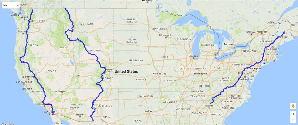
Add these three trails together and you have the Triple Crown of Hiking. These are the longest hiking trails in the US. Covering 22 states in over 7,900 miles and 1 million+ vertical feet, it’s easy to see why only a few hundred people have completed the Triple Crown of Hiking. It’s one of the mightiest hiking feats in the United States.
The Triple Crown of Hiking is officially recognized by the American Long Distance Hiking Association – West. The ALDHA-West awards all people who complete the Triple Crown with a plaque and a poster. Anyone can apply and awards are handed out on the honor system. There are records of all Triple Crowners since 1994 in the ALDHA-West’s database.
The first person to complete the triple crown was Eric Ryback in 1972. The youngest was Christian “Buddy Backpacker” Thomas, age 9, who completed the Triple Crown in 2017. Matthew Hazley was the first person to complete all three hikes back to back in an amazing 239 days.
Let’s take a closer look at what the Triple Crown of Hiking consists of:
Appalachian Trail – 2,184 miles | 3515 km

- Established in 1968, the AT is a National Scenic Trail that journeys from Springer Mountain, Georgia to Mount Katahdin, Maine. It covers 2,184 miles | 3515 km, gains 464,500′, and crosses 14 states (Georgia, North Carolina, Tennessee, Virginia, West Virginia, Maryland, Pennsylvania, New Jersey, New York, Connecticut, Massachusetts, Vermont, New Hampshire, Maine). The highest point is Clingmans Dome (6,643′ | 2,025 m) and the low point is Bear Mountain State Park (124′ | 38 m).
- For more information visit the Appalachian Trail Conservancy. For a map visit PostHoler.com.
Pacific Crest Trail – 2650 mi | 4265 km
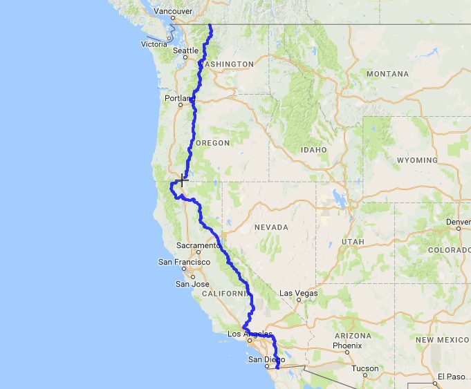
- Established in 1968, the PCT is a National Scenic Trail that starts in Campo, California and ends in Manning Park, BC. It covers 2650 mi | 4265 km and has 420,880′ | 128,284 m of elevation change all while crossing the states of California, Oregon, and Washington en route from Mexico to Canada. The PCT crosses 57 mountain passes, 19 major canyons, and passes by 1000 lakes and dams.
- The PCT travels through 4 national monuments, 5 state park units, 6 national parks, 7 BLM field offices, 25 national forest units and 48 federal wilderness areas. The highest point is Forester Pass – 13,153′ | 4009 m and the low point is Cascade Locks – 140’| 43 m.
- For more information visit the Pacific Crest Trail Association. For a map visit PostHoler.com.
Continental Divide Trail – 3,100 miles | 5,000 km

- Established by Congress on November 10, 1978, the CDT is a National Scenic Trail that connects Mexico to Canada via a 3,100 miles | 5,000 km trail along the spine of the continent. The CDT begins at one of three points (Crazy Cook Monument/Antelope Wells/Columbus) in New Mexico and terminates in Glacier National Park in Montana.
- It crosses 5 states – New Mexico, Colorado, Wyoming, Idaho, Montana and enters 25 National Forests, 21 Wilderness Areas, 3 National Parks, 1 National Monument, 8 BLM Resource Areas. The highest point on the CDT is Grays Peak in Colorado at 14,270′ and the lowest point is Waterton Lake at 4,200′ in Glacier National Park in Montana
- For more information visit the Continental Divide Trail Coalition. For a map visit PostHoler.com.
Do you have what it takes to hike the Pacific Crest Trail, the Continental Divide Trail, and the Appalachian Trail? Are you ready to join the elite crew of thru hikers who have completed the Triple Crown of Hiking? That’s 7,900 miles and over 1 million vertical feet of elevation. It’s a burly mission to complete all three of these iconic hiking trails in the United States, but what an adventure!


