
In 1968, the US Congress created the National Wild and Scenic Rivers System “to preserve certain rivers with outstanding natural, cultural, and recreational values in a free-flowing condition for the enjoyment of present and future generations.” If you love rivers, you should definitely support protecting the rivers of the United States.
![]()
- “Wild River Areas – Those rivers or sections of rivers that are free of impoundments and generally inaccessible except by trail, with watersheds or shorelines essentially primitive and waters unpolluted. These represent vestiges of primitive America.
- Scenic River Areas – Those rivers or sections of rivers that are free of impoundments, with shorelines or watersheds still largely primitive and shorelines largely undeveloped, but accessible in places by roads.
- Recreational River Areas – Those rivers or sections of rivers that are readily accessible by road or railroad, that may have some development along their shorelines, and that may have undergone some impoundment or diversion in the past.”
The original 8 protected rivers included the Clearwater, Eleven Point, Feather, Rio Grande, Rogue, St. Croix, Salmon, and Wolf. As of August 2018, the National Wild and Scenic Rivers System “protects 12,754 miles of 209 rivers in 40 states and the Commonwealth of Puerto Rico; this is less than one-quarter of one percent of the nation’s rivers” (Rivers.gov). These rivers are managed by government agencies like the National Park Service, US Forest Service, Fish & Wildlife, Bureau of Land Management, Local Governments, and other organizations.
New rivers are designated as wild, scenic, or recreational regularly. For more information on The National Wild And Scenic Rivers System, please visit Rivers.gov.
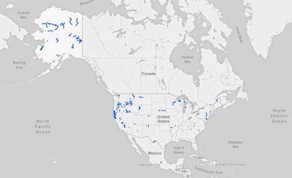
Now let’s take a closer look at the rivers protected by the Wild and Scenic Rivers System:
| River | State | Wild (Miles) | Scenic (Miles) | Recreational (Miles) | Total Miles | Date Designated (YYYYMMDD) | Agency |
|---|---|---|---|---|---|---|---|
| Snake River Headwaters | WY | 236.9 | 141.5 | 33.8 | 412.2 | 20090330 | USFS, NPS |
| Eel | CA | 97.0 | 28.0 | 273.0 | 398.0 | 19810119 | CA, USFS, BLM, RVIR |
| Fortymile | AK | 179.0 | 203.0 | 10.0 | 392.0 | 19801202 | BLM |
| Noatak | AK | 330.0 | 0 | 0 | 330.0 | 19801202 | NPS |
| Smith | CA | 78.0 | 31.0 | 216.4 | 325.4 | 19810119, 19901116 | CA, USFS |
| Klamath | CA, OR | 11.7 | 34.5 | 250.8 | 297.0 | 19810119, 19940922 | CA, USFS, FLM, HVIR, NPS, OR |
| Andreafsky | AK | 262.0 | 0 | 0 | 262.0 | 19801202 | USFW |
| Rio Grande | NM, TX | 150.1 | 108.5 | 0.8 | 259.4 | 19681002, 19940504, 19781110 | USFS, BLM, NPS |
| St Croix | MN, WI | 0 | 193.0 | 59.0 | 252.0 | 19681002, 19721025, 19760617 | NPS, MN, WI |
| Missouri | MT, NE, SD | 64.0 | 26.0 | 157.0 | 247.0 | 19761012, 19781110, 19910524 | BLM, NPS |
| Nowitna | AK | 225.0 | 0 | 0 | 225.0 | 19801202 | USFW |
| Flathead | MT | 97.9 | 40.7 | 80.4 | 219.0 | 19761012 | USFS, NPS |
| Charley | AK | 208.0 | 0 | 0 | 208.0 | 19801202 | NPS |
| Trinity | CA | 44.0 | 39.0 | 120.0 | 203.0 | 19810119 | CA, USFS, BLM,. HVIR |
| White Clay Creek | DE, PA | 0 | 31.4 | 167.7 | 199.0 | 20001024, 20141219 | NPS, LG |
| Clearwater - Middle Fork | ID | 54.0 | 0 | 131.0 | 185.0 | 19681002 | USFS |
| Gulkana | AK | 181.0 | 0 | 0 | 181.0 | 19801202 | BLM |
| Delaware | NY, NJ, PA | 0 | 83.5 | 97.2 | 180.7 | 19781110,20001101 | NPS, LG |
| Deschutes | OR | 0 | 31.0 | 143.4 | 174.4 | 19881028 | USFS, BLM |
| Ontonagon | MI | 43.0 | 35.0 | 92.0 | 170.0 | 19920303 | USFS |
| Virgin | UT | 145.4 | 11.3 | 12.6 | 169.3 | 20090330 | NPS, BLM |
| Selawik | AK | 160.0 | 0 | 0 | 160.0 | 19801202 | USFW |
| Sheenjek | AK | 160.0 | 0 | 0 | 160.0 | 19801202 | USFW |
| Skagit | WA | 0 | 100.0 | 58.5 | 158.5 | 19781110 | USFS |
| Kern | CA | 123.1 | 7.0 | 20.9 | 151.0 | 19871124 | USFS, NPS |
| John Day | OR | 0 | 0 | 147.5 | 147.5 | 19881028 | BLM |
| Wind | AK | 140.0 | 0 | 0 | 140.0 | 19801202 | USFW |
| Great Egg Harbor | NJ | 0 | 30.6 | 98.4 | 129.0 | 19921027 | NPS |
| Beaver Creek | AK | 127.0 | 0 | 0 | 127.0 | 19801202 | USFW, BLM |
| Birch Creek | AK | 126.0 | 0 | 0 | 126.0 | 19801202 | BLM |
| Salmon | ID | 79.0 | 0 | 46.0 | 125.0 | 19800723 | USFS |
| Merced | CA | 71.0 | 16.0 | 35.5 | 122.5 | 19871102, 19921023 | USFS, NPS, BLM |
| Owyhee | OR | 120.0 | 0 | 0 | 120.0 | 19841019 | BLM |
| Kobuk | AK | 110.0 | 0 | 0 | 110.0 | 19801202 | NPS |
| Niobrara | NE | 0 | 76.0 | 28.0 | 104.0 | 19910524 | NPS. USFW |
| Salmon - Middle Fork | ID | 103.0 | 1.0 | 0 | 104.0 | 19681002 | USFS |
| Koyukuk - North Fork | AK | 102.0 | 0 | 0 | 102.0 | 19801202 | NPS |
| Big and Little Darby Creeks | OH | 0 | 85.9 | 0 | 95.9 | 19940310 | OH |
| Little Miami | OH | 0 | 18.0 | 76.0 | 94.0 | 19730820, 19810111 | OH |
| Allagash Wilderness Waterway | ME | 92.5 | 0 | 0 | 92.5 | 19700719 | ME |
| Donner und Blitzen | OR | 87.5 | 0 | 0 | 87.5 | 19881028, 20001030 | BLM |
| Allegheny | PA | 0 | 0 | 86.6 | 86.6 | 19920420 | USFS |
| Rogue | OR | 33.6 | 7.5 | 43.4 | 84.5 | 19861002 | USFS, BLM |
| Alatna | AK | 83.0 | 0 | 0 | 83.0 | 19801202 | NPS |
| Tuolumne | CA | 47.0 | 13.0 | 23.0 | 83.0 | 19840928 | USFS, NPS, BLM |
| Kings | CA | 65.5 | 0 | 15.5 | 81.0 | 19871103 | USFS, NPS |
| Lumber | NC | 0 | 60.0 | 21.0 | 81.0 | 19980925 | NC |
| Unalakleet | AK | 80.0 | 0 | 0 | 80.0 | 19801202 | BLM |
| Ivishak | AK | 80.0 | 0 | 0 | 80.0 | 19801202 | USFW |
| Westfield | MA | 2.6 | 42.9 | 32.6 | 78.1 | 19931102, 20040928 | MA |
| Feather | CA | 32.9 | 9.7 | 35.0 | 77.6 | 19681002 | USFS |
| Imnaha | OR | 15.0 | 4.0 | 58.0 | 77.0 | 19881028 | USFS |
| Cache La Poudre | CO | 30.0 | 0 | 46.0 | 76.0 | 19861030 | USFS, NPS |
| Presque Isle | MI | 0 | 24.0 | 48.0 | 72.0 | 19920303 | USFS |
| Salmon | AK | 70.0 | 0 | 0 | 70.0 | 19801202 | NPS |
| Snake | ID, OR | 31.5 | 36.0 | 0 | 67.5 | 19751231 | USFS |
| Owyhee | ID | 67.3 | 0 | 0 | 67.3 | 20090330 | BLM |
| Alagnak | AK | 67.0 | 0 | 0 | 67.0 | 19801202 | NPS |
| Pere Marquette | MI | 0 | 66.4 | 0 | 66.4 | 19781110 | USFS |
| Saint Joe | ID | 26.6 | 0 | 39.7 | 66.3 | 19781110 | USFS |
| Aniakchak | AK | 63.0 | 0 | 0 | 63.0 | 19801202 | NPS |
| Delta | AK | 20.0 | 24.0 | 18.0 | 62.0 | 19801202 | BLM |
| Sipsey Fork West Fork (aka Sipsey Fork of the Black Warrior River | AL | 36.4 | 25.0 | 0 | 61.4 | 19881028 | USFS |
| Sycan | OR | 0 | 50.4 | 8.6 | 59.0 | 19881028 | USFS |
| Chattooga | GA, NC, SC | 41.6 | 2.5 | 14.6 | 58.7 | 19740510 | USFS |
| West Little Owyhee | OR | 57.6 | 0 | 0 | 57.6 | 19881028 | BLM |
| Mulberry | AR | 0 | 19.4 | 36.6 | 56.0 | 19920422 | USFS |
| John Day - North Fork | OR | 27.8 | 10.5 | 15.8 | 54.1 | 19881028 | USFS |
| Paint | MI | 0 | 0 | 52.0 | 52.0 | 19920303 | USFS |
| John | AK | 52.0 | 0 | 0 | 52.0 | 19801202 | NPS |
| Clarion | PA | 0 | 17.1 | 34.6 | 51.7 | 19961019 | USFS |
| Tlikakila | AK | 51.0 | 0 | 0 | 51.0 | 19801202 | NPS |
| Indian | MI | 0 | 12.0 | 39.0 | 51.0 | 19920303 | USFS |
| Illinois | OR | 28.7 | 17.9 | 3.8 | 50.4 | 19841019 | USFS |
| Clackamas | OR | 0 | 20.0 | 27.0 | 47.0 | 19881028 | USFS |
| White | OR | 0 | 24.3 | 22.5 | 46.8 | 19881028 | USFS, BLM |
| Missisquoi & Trout | VT | 0 | 0 | 46.1 | 46.1 | 20141219 | NPS, LG |
| Obed | TN | 43.3 | 2.0 | 0 | 45.3 | 19761012 | NPS |
| Big Piney Creek | AR | 0 | 45.2 | 0 | 45.2 | 19920422 | USFS |
| Chetco | OR | 25.5 | 8.0 | 11.0 | 44.5 | 19881028 | USFS |
| Eleven Point | MO | 0 | 44.4 | 0 | 44.4 | 19681002 | USFS |
| Tinayguk | AK | 44.0 | 0 | 0 | 44.0 | 19801202 | NPS |
| Sturgeon - Hiawatha National Forest | MI | 0 | 21.7 | 22.2 | 43.9 | 19920303 | USFS |
| Grande Ronde | OR | 26.4 | 0 | 17.4 | 43.8 | 19881028 | USFS, BLM |
| Williamette - North Fork Middle Fork | OR | 8.8 | 6.5 | 27.0 | 42.3 | 19881028 | USFS |
| Minam | OR | 41.9 | 0 | 0 | 41.9 | 19881028 | USFS |
| Wekiva | FL | 31.4 | 2.1 | 8.1 | 41.6 | 20001013 | NPS, FL |
| Verde | AZ | 22.2 | 18.3 | 0 | 40.5 | 19840828 | USFS |
| Rogue - Upper | OR | 6.1 | 34.2 | 0 | 40.3 | 19881028 | USFS |
| Taunton | MA | 0 | 26.0 | 14.0 | 40.0 | 20090330 | NPS |
| Bruneau | ID | 38.7 | 0 | 0.6 | 39.3 | 20090330 | BLM |
| American - North Fork | CA | 38.3 | 0 | 0 | 38.3 | 19781110 | USFS, BLM |
| Maurice | NJ | 0 | 28.9 | 6.5 | 35.4 | 19931201 | NPS |
| Big Jacks Creek | ID | 35.0 | 0 | 0 | 35.0 | 20090330 | BLM |
| North Umpqua | OR | 0 | 0 | 33.8 | 33.8 | 19881028 | USFS, BLM |
| Crooked - North Fork | OR | 12.2 | 8.2 | 13.3 | 33.7 | 19881028 | USFS, BLM |
| Whitefish | MI | 0 | 31.5 | 2.1 | 33.6 | 19920303 | USFS |
| Salmon | OR | 15.0 | 4.8 | 13.7 | 33.5 | 19881028 | USFS, BLM |
| Sisquoc | CA | 33.0 | 0 | 0 | 33.0 | 19920619 | USFS |
| Little Beaver | OH | 0 | 33.0 | 0 | 33.0 | 19751023 | OH |
| Sespe Creek | CA | 27.5 | 4.0 | 0 | 31.5 | 19920619 | USFS |
| Owyhee - South Fork | ID | 30.2 | 0 | 1.2 | 31.4 | 20090330 | ZBLM |
| Cossatot | AR | 0 | 26.6 | 4.2 | 30.8 | 19920422, 19940114 | USFS, ACE, AR |
| Sudbury, Assabet, Concord | MA | 0 | 14.9 | 14.1 | 29.0 | 19990409 | NPS, MA, LG |
| Eagle Creek | OR | 4.5 | 6.0 | 18.4 | 28.9 | 19881028 | USFS |
| Jarbidge | ID | 28.8 | 0 | 0 | 28.8 | 20090330 | BLM |
| Metolius | OR | 0 | 17.1 | 11.5 | 28.6 | 19881028 | USFS |
| Elk | OR | 9.7 | 1.5 | 17.0 | 28.2 | 19881028, 20090330 | USFS |
| Sturgeon - Ottawa National Forest | MI | 20.0 | 8.0 | 0 | 28.0 | 19920303 | USFS |
| Carp | MI | 12.4 | 9.3 | 6.1 | 27.8 | 19920303 | USFS |
| White Salmon | WA | 06.7 | 21.0 | 0 | 27.7 | 19861117, 20050802 | USFS |
| Snoqualmie - Middle Fork | WA | 6.4 | 21.0 | 0 | 27.4 | 20141219 | USFS |
| Rapid | ID | 26.8 | 0 | 0 | 26.8 | 19751231 | USFS |
| New | NC | 0 | 26.5 | 0 | 26.5 | 19760413 | NC |
| Amargosa | CA | 7.9 | 12.1 | 6.3 | 26.3 | 20090330 | BLM |
| Manistee | MI | 0 | 0 | 26.0 | 26.0 | 19920303 | USFS |
| Sheep Creek | ID | 25.6 | 0 | 0 | 25.6 | 20090330 | BLM |
| Malheur - North Fork | OR | 0 | 25.5 | 0 | 25.5 | 19881028 | USFS |
| Eightmile | CT | 0 | 25.3 | 0 | 25.3 | 20080508 | NPS, LG |
| Pine | MI | 0 | 25.0 | 0 | 25.0 | 19920303 | USFS |
| Sandy | OR | 4.5 | 3.8 | 16.6 | 24.9 | 19881028 | USFS, BLM |
| Rio Chama | NM | 21.6 | 3.0 | 0 | 24.6 | 19881107 | USFS, BLM |
| Musconetcong | NJ | 0 | 3.5 | 20.7 | 24.2 | 20061222 | NPS |
| Wolf | WI | 0 | 24.0 | 0 | 24.0 | 19681002 | NPS |
| Mulchatna | AK | 24.0 | 0 | 0 | 24.0 | 19801202 | NPS |
| Lamprey | NH | 0 | 0 | 23.5 | 23.5 | 19961112, 20000502 | NPS, LG |
| Battle Creek | ID | 23.4 | 0 | 0 | 23.4 | 20090330 | BLM |
| Wilson Creek | NC | 4.6 | 2.9 | 15.8 | 23.3 | 20000818 | USFS |
| Au Sable | MI | 0 | 23.0 | 0 | 23.0 | 19841004 | USFS |
| American - Lower | CA | 0 | 0 | 23.0 | 23.0 | 19810119 | CA |
| Wenaha | OR | 18.7 | 2.7 | 0.2 | 21.6 | 19881028 | USFS |
| Cottonwood Creek | CA | 17.4 | 0 | 4.1 | 21.5 | 20090330 | USFS, BLM |
| Black Butte | CA | 17.5 | 3.5 | 0 | 21.0 | 20061017 | USFS |
| Black Creek | MI | 0 | 21.0 | 0 | 21.0 | 19861030 | USFS |
| Owyhee - North Fork | ID | 15.1 | 0 | 5.7 | 20.8 | 20090330 | BLM |
| Yellowstone - Clarks Fork | WY | 20.5 | 0 | 0 | 20.5 | 19901128 | USFS |
| Pecos | NM | 13.5 | 0 | 7.0 | 20.5 | 19900606 | USFS |
| East Rosebud Creek | MT | 13.0 | 0 | 7.0 | 20.0 | 20180802 | USFS |
| Big Sur | CA | 19.5 | 0 | 0 | 19.5 | 19920619 | USFS |
| Red | KY | 9.1 | 0 | 10.3 | 19.4 | 19931202 | USFS |
| Owens River Headwaters | CA | 6.3 | 6.6 | 6.2 | 19.1 | 20090330 | USFS |
| Saline Bayou | LA | 0 | 19.0 | 0 | 19.0 | 19861030 | USFS |
| Collawash | OR | 0 | 11.0 | 6.8 | 17.8 | 20090330 | USFS |
| Crooked | OR | 0 | 0 | 17.8 | 17.8 | 19881028 | BLM |
| Vermilion - Middle Fork | IL | 0 | 17.1 | 0 | 17.1 | 19890511 | IL |
| Fossil Creek | AZ | 9.3 | 0 | 7.5 | 16.8 | 20090330 | USFS |
| Richland Creek | AR | 5.3 | 11.2 | 0 | 16.5 | 19920422 | USFS |
| Lostine | OR | 5.0 | 0 | 11.0 | 16.0 | 19881028 | USFS |
| Buffalo | AR | 9.4 | 6.4 | 0 | 15.8 | 19920422 | USFS |
| Little Missouri | AR | 4.4 | 11.3 | 0 | 15.7 | 19920422 | USFS |
| Hurricane Creek | AR | 2.4 | 13.1 | 0 | 15.5 | 19920422 | USFS |
| Squaw Creek (aka Whychus Creek) | OR | 6.6 | 8.8 | 0 | 15.4 | 19881028 | USFS |
| Sprague - North Fork | OR | 0 | 15.0 | 0 | 15.0 | 19881028 | USFS |
| Big Marsh Creek | OR | 0 | 0 | 15.0 | 15.0 | 19881028 | USFS |
| North Sylamore Creek | AR | 0 | 14.5 | 0 | 14.5 | 19920422 | USFS |
| Wildcat | NH | 0 | 13.7 | 0.8 | 14.5 | 19881028 | USFS |
| Illabot Creek | WA | 4.3 | 0 | 10.0 | 14.3 | 20141219 | USFS |
| Black | MI | 0 | 14.0 | 0 | 14.0 | 19920303 | USFS |
| Farmington - West Branch | CT | 0 | 0 | 14.0 | 14.0 | 19940826 | NPS, CT, LG |
| WIldhorse & Kiger Creeks | OR | 13.9 | 0 | 0 | 13.9 | 20001030 | BLM |
| Roaring | OR | 13.5 | 0 | 0.2 | 13.7 | 19881028 | USFS |
| Malheur | OR | 6.7 | 7.0 | 0 | 13.7 | 19881028 | USFS |
| Fish Creek | OR | 0 | 0 | 13.5 | 13.5 | 20090330 | USFS |
| Hood - East Fork | OR | 0 | 0 | 13.5 | 13.5 | 20090330 | USFS |
| Tahquamenon - East Branch | MI | 3.2 | 0 | 10.0 | 13.2 | 19920303 | USFS |
| Deep Creek | ID | 13.1 | 0 | 0 | 13.1 | 20090330 | BLM |
| Smith - North Fork | OR | 8.5 | 4.5 | 0 | 13.0 | 19881028 | USFS |
| McKenzie | OR | 0 | 0 | 12.7 | 12.7 | 19881028 | USFS |
| LIttle Jacks Creek | ID | 12.4 | 0 | 0 | 12.4 | 20090330 | BLM |
| Quartzville Creek | OR | 0 | 0 | 12.0 | 12.0 | 19881028 | BLM |
| Little Deschutes | OR | 0 | 0 | 12.0 | 12.0 | 19881028 | USFS |
| Powder | OR | 0 | 11.7 | 0 | 11.7 | 19881028 | BLM |
| Fifteenmile Creek | OR | 10.5 | 0.6 | 0 | 11.1 | 20090330 | USFS |
| Jemez - East Fork | NM | 4.0 | 5.0 | 2.0 | 11.0 | 19900606 | USFS |
| Chilikadrotna | AK | 11.0 | 0 | 0 | 11.0 | 19801202 | NPS |
| Klickitat | WA | 0 | 0 | 10.8 | 10.8 | 19861117 | USFS |
| San Jacinto - North Fork | CA | 7.2 | 2.3 | 0.7 | 10.2 | 20090330 | USFS |
| Crescent Creek | OR | 0 | 0 | 10.0 | 10.0 | 19881028 | USFS |
| Bluestone | WV | 0 | 10.0 | 0 | 10.0 | 19881026 | NPS |
| Wallowa | OR | 0 | 0 | 10.0 | 10.0 | 19960723 | OR, BLM |
| Bautista Creek | CA | 0 | 0 | 9.8 | 9.8 | 20090330 | USFS |
| Owyhee - North Fork | OR | 9.6 | 0 | 0 | 9.6 | 19881028 | BLM |
| Pratt | WA | 9.5 | 0 | 0 | 9.5 | 20141219 | USFS |
| Dickshooter Creek | ID | 9.3 | 0 | 0 | 9.3 | 20090330 | BLM |
| Joseph Creek | OR | 8.6 | 0 | 0 | 8.6 | 19881028 | USFS |
| Eagle Creek | OR | 8.3 | 0 | 0 | 8.3 | 20090330 | USFS |
| Palm Canyon Creek | CA | 8.1 | 0 | 0 | 8.1 | 20090330 | USFS |
| Loxahatchee | FL | 1.3 | 5.8 | 0.5 | 7.6 | 19850517 | FL |
| Piru Creek | CA | 4.3 | 0 | 3.0 | 7.3 | 20090330 | USFS |
| Bear Creek | MI | 0 | 6.5 | 0 | 6.5 | 19920303 | USFS |
| North Powder | OR | 0 | 6.4 | 0 | 6.4 | 19881028 | USFS |
| Elkhorn Creek | OR | 5.8 | 0.6 | 0 | 6.4 | 19960930 | USFS, BLM |
| Red Canyon | ID | 4.6 | 0 | 0 | 4.6 | 20090330 | BLM |
| Roaring - South Fork | OR | 4.6 | 0 | 0 | 4.6 | 20090330 | USFS |
| Rio Mameyes | PR | 2.1 | 1.4 | 1.0 | 4.5 | 20021219 | USFS |
| Zigzag | OR | 4.3 | 0 | 0 | 4.3 | 20090330 | USFS |
| Clackamas - South Fork | OR | 4.2 | 0 | 0 | 4.2 | 20090330 | USFS |
| Horsepasture | NC | 0 | 3.6 | 0.6 | 4.2 | 19861026 | USFS |
| Yellow Dog | MI | 4.0 | 0 | 0 | 4.0 | 19920303 | USFS |
| Hood - Middle Fork | OR | 0 | 3.7 | 0 | 3.7 | 20090330 | USFS |
| Fuller Mill Creek | CA | 0 | 2.6 | 0.9 | 3.5 | 20090330 | USFS |
| Cottonwood Creek | ID | 2.6 | 0 | 0 | 2.6 | 20090330 | BLM |
| Rio Icacos | PR | 0 | 2.3 | 0 | 2.3 | 20021219 | USFS |
| Rio de la Mina | PR | 0 | 1.2 | 0.9 | 2.1 | 20021219 | USFS |
| Wickahoney Creek | ID | 1.5 | 0 | 0 | 1.5 | 20090330 | BLM |
| Duncan Creek | ID | 0.9 | 0 | 0 | 0.9 | 20090330 | BLM |
| River Styx (Cave Creek) | OR | 0 | 0.4 | 0 | 0.4 | 20141219 | NPS |
| Bruneau - West Fork | ID | 0.4 | 0 | 0 | 0.4 | 20090330 | BLM |
| John Day - South Fork | OR | 0 | 0 | 47.0 | 0 | 19881028 | BLM |
| TOTALS: | 6219.9 | 2751.8 | 3781.8 | 12753.5 |
Below you will find information about wild and scenic rivers by state. Please click on the state name for more information about the designated rivers in each state.
Alabama
- Total River Miles: 77,242
- Wild & Scenic Miles: 61.4
Alaska
- Total River Miles: 365,000
- Wild & Scenic Miles: 3,210
Arizona
- Total River Miles:
- 90,373
- Wild & Scenic Miles: 57.3
Arkansas
- Total River Miles: 82,366
- Wild & Scenic Miles: 210
California
- Total River Miles: 189,454
- Wild & Scenic Miles: 1,999.6
Colorado
- Total River Miles: 107,403
- Wild & Scenic Miles: 76
Connecticut
- Total River Miles: 5,828
- Wild & Scenic Miles: 39.3
Delaware
- Total River Miles: 2,183
- Wild & Scenic Miles: 94.7
Florida
- Total River Miles: 25,949
- Wild & Scenic Miles: 49.2
Georgia
- Total River Miles: 69,547
- Wild & Scenic Miles: 49.2
Hawaii
- Total River Miles: 3,905
- Wild & Scenic Miles: 0
Idaho
- Total River Miles: 107,651
- Wild & Scenic Miles: 891
Illinois
- Total River Miles: 86,076
- Wild & Scenic Miles: 17.1
Indiana
- Total River Miles: 35,673
- Wild & Scenic Miles: 0
Iowa
- Total River Miles: 70,247
- Wild & Scenic Miles: 0
Kansas
- Total River Miles: 133,956
- Wild & Scenic Miles: 0
Kentucky
- Total River Miles: 49,105
- Wild & Scenic Miles: 19.4
Louisiana
- Total River Miles: 53,622
- Wild & Scenic Miles: 19
Maine
- Total River Miles: 31,752
- Wild & Scenic Miles: 92.5
Maryland
- Total River Miles: 16,839
- Wild & Scenic Miles: 0
Massachusetts
- Total River Miles: 8,229
- Wild & Scenic Miles: 147.1
Michigan
- Total River Miles: 51,438
- Wild & Scenic Miles: 656.4
Minnesota
- Total River Miles: 91,944
- Wild & Scenic Miles:226
Mississippi
- Total River Miles: 81,316
- Wild & Scenic Miles: 21
Missouri
- Total River Miles: 51,978
- Wild & Scenic Miles: 44.4
Montana
- Total River Miles: 169,829
- Wild & Scenic Miles: 388
Nebraska
- Total River Miles: 79,056
- Wild & Scenic Miles: 197
Nevada
- Total River Miles: 141.796
- Wild & Scenic Miles: 0
New Hampshire
- Total River Miles: 10,874
- Wild & Scenic Miles: 38
New Jersey
- Total River Miles: 6,450
- Wild & Scenic Miles: 262.9
New Mexico
- Total River Miles: 108,014
- Wild & Scenic Miles: 124.3
New York
- Total River Miles: 51,790
- Wild & Scenic Miles: 73.4
North Carolina
- Total River Miles: 37,853
- Wild & Scenic Miles: 144.5
North Dakota
- Total River Miles: 54,373
- Wild & Scenic Miles: 0
Ohio
- Total River Miles: 29,113
- Wild & Scenic Miles: 212.9
Oklahoma
- Total River Miles: 78,603
- Wild & Scenic Miles: 0
Oregon
- Total River Miles: 110,994
- Wild & Scenic Miles: 1,916.7
Pennsylvania
- Total River Miles: 83,260
- Wild & Scenic Miles: 409.3
Puerto Rico
- Total River Miles: 5,385
- Wild & Scenic Miles: 8.9
Rhode Island
- Total River Miles: 1,392
- Wild & Scenic Miles: 0
South Carolina
- Total River Miles: 29,898
- Wild & Scenic Miles: 41.9
South Dakota
- Total River Miles: 9,513
- Wild & Scenic Miles: 93
Tennessee
- Total River Miles: 61,075
- Wild & Scenic Miles: 45.3
Texas
- Total River Miles: 184,797
- Wild & Scenic Miles: 191.2
Utah
- Total River Miles: 81,899
- Wild & Scenic Miles: 169.3
Vermont
- Total River Miles: 7,099
- Wild & Scenic Miles: 46.1
Virginia
- Total River Miles: 49,350
- Wild & Scenic Miles: 0
Washington
- Total River Miles: 70,439
- Wild & Scenic Miles: 197
West Virginia
- Total River Miles: 32,260
- Wild & Scenic Miles: 10
Wisconsin
- Total River Miles: 56,884
- Wild & Scenic Miles: 276
Wyoming
- Total River Miles: 108,767
- Wild & Scenic Miles: 408
Hopefully this post will inspire you to enjoy and protect the spectacular rivers that criss cross the United States. Maybe you’re next adventure will take you on one of the stunning wild and scenic rivers in the United States.
See Also:
- 10 Largest Wilderness Areas In The Lower 48
- 10 Largest Wilderness Areas In The United States
- List Of US National Forests By State


