
Hiking To No Man Lake In Montana’s Madison Range
Location: No Man Lake, Taylor Hilgard Unit, Lee Metcalf Wilderness, Madison Range, Montana
Type: Out and Back
Rating: Grade II Class 2
Trailhead: Indian Creek Trailhead – 6075′
Distance: 20 miles round trip
Time: 6 to 12 hours round trip
No Man Lake Elevation: 9,188′
Total Vertical: 3750′
Lat/Long: 45 4.1879 N / 111 29.3614 W
Maps: No Man Peak, Koch Peak
Find More Montana Trip Reports
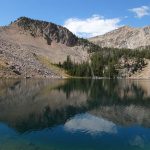
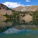
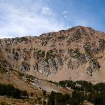
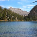
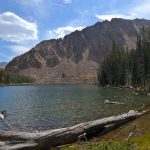
No Man Lake is a dammed reservoir/alpine lake in the Taylor Hilgard unit of the Lee Metcalf Wilderness in the Madison Range of Montana. Sitting at 9,188′ in the cirque to the east of No Man Peak, No Man Lake is a remote mountain lake that’s well worth the hike to access it.

There is very little information available about No Man Lake, so hiking up there was a bit of an adventure – especially after going big on Hilgard Peak the day before. But that’s what makes the mountains fun.
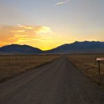
Bright and early on an August morning, Jeremy Wood and I decided it would be wise to drive around the Madison Range and hike to No Man Lake. We turned off of Highway 287 south of Ennis and rumbled down the dirt road toward the Indian Creek Trailhead as the sun began to crest over the Madison Range.

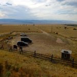
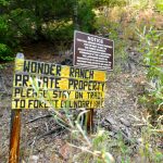
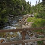
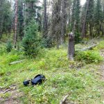
We pulled into the large Indian Creek Trailhead parking lot at 6078′ and parked the van. It is not located in the same place that most maps mark it – most likely due to private land easements in the area. We geared up, used the outhouse at the parking area, and hit the trail. Sticking to the trail across the private land, we gained a bit of elevation, crossed a field, went through a gate, and dropped down to a road that parallels Indian Creek. We soon crossed the creek on a bridge and walked through the grassy yard of the Wonder Ranch.

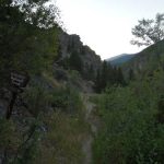
Shortly after passing the Wonder Ranch we hit the Beaverhead Deerlodge National Forest Boundary and then in a hop skip and a jump we entered the Lee Metcalf Wilderness. The well trodden trail #328 parallels Indian Creek until it crossed the creek on a bridge at 6312′.


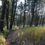
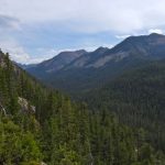
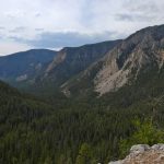
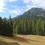
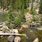
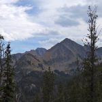
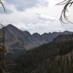
After this bridge, the mellow trail continues to follow the creek and roll along the terrain through open forests and scenic meadows. Large peaks tower overhead to the north. It’s stunning terrain. Walking east into the rising sun gave the forests a surreal feel as we cruised along the trail.


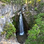
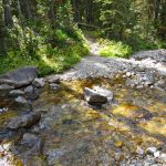
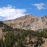
There were a surprising number of elaborate bridges along the trail – not something one usually expects in a wilderness area. But it kept our socks dry so it made us happy. After 4.5 miles and 925′ of gain we reached an overlook that dropped steeply down to a beautiful waterfall that plummeted out of No Man Creek. It must have been 100′ tall.

Trail #328 continues onwards and we kept moving. About a mile after the falls we came to an unmarked trail split at 7050′ and roughly 5.2 miles. After scratching our heads and wondering if this was our turn off. We decided to hoof it up the steep trail and came to a cool overlook that gazes up No Man Creek and down Indian Creek. The trail seemed more apparent here and based on GAIA GPS we knew we were now on Trail 329 that parallels No Man Creek through the forests.


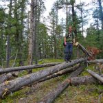
This is where the adventure really began. Due to reasons unknown to us, there were hundreds of downed trees that had fallen across the trail. Literally hundreds of large obstacles that we had to climb up, tip toe along, scoot under, or bushwhack around. The worst of it was over by the time we crossed No Man Creek around 7800′.


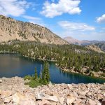
After crossing No Man Creek, we continued slowly working up the trail navigating around tree obstacles. Eventually the trail started to switchback up and then finally mellowed out as we approached No Man Lake at 9188′. We reached No Man Lake in 4.5 hours, 9.75 miles, and 3575′. If the trail had been in good shape I think we could have easily shaved an hour off of that time. In the back of our heads we knew we had to go back through the land where dead trees go to die to get out of here, but in the meantime we were in a stunning locale.

No Man Lake is definitely a dammed reservoir. Why is it dammed? I have no idea. A rock dam on the east side keeps the water in place. Decaying cement structures are built nearby and there are a few items (sledges, horseshoes, etc) from a different time scattered around the place. There are plenty of amazing places to camp too.

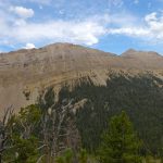
Now, our goal wasn’t really just hiking to No Man Lake. Our goal was to climb No Man Peak. We carefully rock hopped around the southern side of the lake and worked our way up toward the peak. At about 10,000′ we stopped for water and decided that today wasn’t the day to summit the peak for a variety of reasons. Instead we skirted around the northern end of No Man Lake, crossed the rock dam, and made our way back to Trail #329.


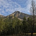
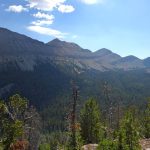
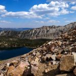
As we headed back down the trail, we caught stunning views of No Man Ridge, Koch Peak, Sawtooth Ridge, and even the Sphinx. Such an amazing zone. Luckily, we’ll be back to tag No Man Peak soon.


Our round trip covered just over 21.3 miles, 10.25 hours, and 5200′. If you just go to the No Man Lake and back the stats would be about 19.5 miles, 3750′, and around 9 hours – just guessing on that though.
View route for hiking to No Man Lake in Montana on HillMap:
Additional photos from hiking to No Man Lake in Montana:
This trip report for hiking to No Man Lake in Montana’s Madison Range is from August 30, 2016.
#amountainjourney #madisonrange #montana #eternalstoke


