
A Mountain Journey’s Backcountry Ski Guide
The Fuhrer Finger, Mount Rainier, Washington
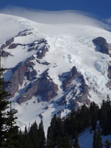
Description:The Fuhrer Finger is a ski mountaineering line that goes descends through complex glaciated terrain into a 40 degree couloir from the summit of Mount Rainier.
State: Washington
Mountain Range: Cascade Range
National Park: Mount Rainier National Park
Mountain: Mount Rainier – 14,416′ | 4,392 m
Route: The Fuhrer Finger
Trailhead: Paradise
Aspect: South
Vertical: 10,000+
Slope Angle: 35 – 45 degrees
USGS Maps: Mount Rainier East, Mount Rainier West
First Descent: Dan Davis, Tom Janisch and Jeff Haley, on May 3, 1980
Guidebook Recommendations:
- 50 Classic Ski Descents Of North America
- Ski and Snowboard Routes Washington – Martin Volken
Trip Reports & Useful Links:
- The Peak Of The Week
- A Mountain Journey
- Skinning With Bear Spray
- SkiMountaineer
- Alpenglow.org
- WildSnow.com
- CascadeCrusades
Do you have photos, trip reports, or other information that you’d like to add? Contact A Mountain Journey.


