
Climbing Follow The Swarm on the East Ridge of Beehive Peak in The Madison Range
Location: Beehive Peak, Spanish Peaks, Lee Metcalf Wilderness, Madison Range, Montana
Trailhead: Beehive Basin Trailhead – 7900 feet
Distance: +/- 8 miles round trip
Time: 5-8 hours
Grade: II, 5.3
Summit Elevation: 10742 feet | 3274 meters
Vertical: 2750 ft
USGS Maps: Lone Mountain
_____________________________________________
July is here. Only intermittent patches of snow still linger in the mountains of Montana. You might be able to sneak in a few turns in select locations, but it’s also time to get into the climbing groove. That’s why Opie Jahn and I decided to head toward Beehive Basin for an alpine adventure.
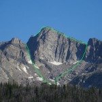
Our objective for the day was to summit Beehive Peak via the East Ridge on a popular route called Follow the Swarm. According to Select Alpine Climbs, by Ron Brunckhorst, this route is a Grade II, 5.3. Other places rate it as 4th class. Turiano calls the East Ridge “one of the most fun easy-class-5 routes in Greater Yellowstone.” As you look at Beehive Peak on the approach, we were going to ascend the ridge on the right skyline. This was going to be awesome.

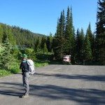
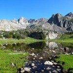
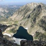
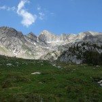
Opie and I arrived to an empty Beehive Basin parking lot, grabbed our Patagonia Ascensionist packs, and hoofed it down the Beehive Basin trail. We cruised down the well-trodden trail at a conversational pace. Before we knew it we were at the picturesque alpine lake where we grabbed some water and soaked in the view of Beehive Peak.


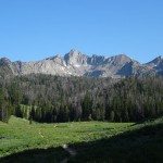
Although it’s not named on most maps, Beehive Peak is the second highest peak in the Spanish Peaks wilderness. It’s towering walls of gneiss are home to multiple climbing routes like What’s Left, Worker Bee, New World Route and others.
The peak is a stunning chunk of rock. The beautiful marbled gneiss has black mafic dikes that scar it with geologic history. The glacially carved moraines are littered with scree and boulders. It’s a peak that’s on par with the Tetons, except much, much smaller. And it’s right in our backyard.

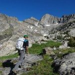
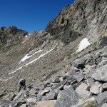
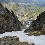
The trail continues on for a bit longer before a fading climbers trail lead us through the moraines and wobbly boulders. Our plan was to climb the Honeycomb Couloir where we would join the East Ridge. The Honeycomb Couloir drops down from the low point on the East Ridge and the rocky walls of Beehive’s neighbor, Honeycomb Peak.


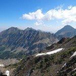
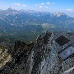
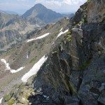
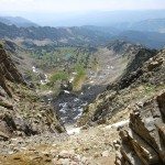
We approached the Honeycomb Couloir and made good time up the loose scree to the East Ridge. At the top, the view of Gallatin Peak, the highest summit in the Spanish Peaks, greeted us. Behind us, Lone Peak, home of Big Sky Resort, sat covered with a slight haze. There must be a fire somewhere in the region. We didn’t spot one, and I secretly hoped my photos from the day would turn out.


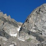
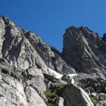
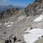
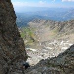
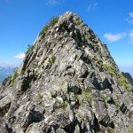
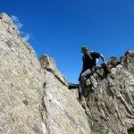
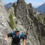
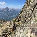
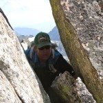
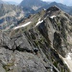
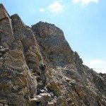
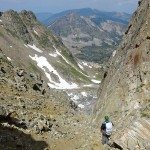
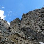
There is nothing super technical on the East Ridge. The one thing that makes this route challenging is the vertigo inducing exposure. The route follows the ridge line, where small grass shelves linked with simple slabby moves and tricky traverses makes for relative easy climbing toward Beehive Peak.
The hardest moves are about half way down the ridge and can easily be done in approach shoes. Most climbers wouldn’t think twice about them except that they are over hundreds of feet of exposure, so just don’t look down. I wouldn’t call it a knife edge ridge, but you certainly don’t want to fall.


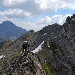
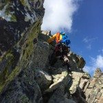
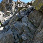
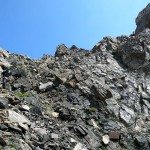
Knowing that there was a bit of loose rock and a few loose boulders on the route, encouraged us to move quickly and efficiently. We decided not to rope up, but had a rope and gear in case we decided to short rope sections or simul-climb. Ultimately we did not use any gear on this route, but it’s reassuring to have it with. As we made good time up Follow The Swarm, we only stopped to appreciate the views, look down other climbing routes, scout out route options, and note the signs of wildlife on a rocky ridge. There were obvious signs of mountain goats that had shed tufts of hair along the route, marmots left their scat, and we may have even seen a wolverine poo up there. Oh, and the few stashes of wildflowers were amazing to see.


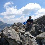
Three and a half hours after we left the car, we were sitting at 10,742 feet on the summit of Beehive Peak enjoying a drink of water and chomping on snacks. In every direction, the hazy views made us smile. We could see Spanish Lakes, Mirror Basin, Beehive Lake, Blaze Mountain, Cedar, Fan, Lone Peak, the Hilgards, the Gallatins, Wilson,, Beacon Point, and so much more. So many places to ski, but where’s all the snow? With no one else around, you realize how much you love Montana.


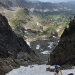
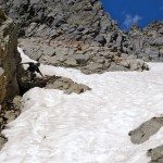
Finally, it was time to head down. Our descent option was the standard 4th class ascent, the 4th of July Couloir. From the summit, we downclimbed a short chimney. Then we stopped to peer down the Hanging Garden and then made good time down to the 4th of July/North Twin saddle.


Whenever I climb Beehive Peak, my least favorite part is descending the 4th of July Couloir. It’s only 4th class terrain, but it’s loose and steep, which makes for uneven and somewhat sketchy footing. I’ve rappelled down this section before, but we only had a 30 meter rope so it didn’t seem worth it. Today, a few patches of firm snow made the descent even more challenging. Unfortunately there was not enough snow to ski though.


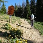
At the bottom of the couloir, we found the climber’s trail and worked our way back to the Beehive Basin Trail. Once on the trail, we were amazed at the steady flow of hikers headed uphill in the blazing heat. Finally, after 6.5 hours we were back at the car, drinking water, and wearing flip flops.

Car-to-car our adventure took 6.5 hours. We covered about 8 miles and 2750 vertical feet. We climbed an easy, low fifth class, alpine ridge route over huge exposure. I guess this is what summer is all about. What should we climb next?
_____________________________________________
Learn more about Follow The Swarm on the East Ridge of Beehive Peak in the following books:
- Select Alpine Climbs to Montana – Ron Brunkhorst
- Bozeman Rock Climbs – Bill Dockins & Tom Kalakay
- Select Peaks of Greater Yellowstone: A Mountaineering History & Guide – Tom Turiano
_____________________________________________
Our route on Hillmap:
_____________________________________________
More photos from our Follow The Swarm climb on Beehive Peak:


